The Logistical Pivot
A strategic realignment of South Carolina’s container flows using assets that already exist
Executive Summary
South Carolina faces two converging pressures: chronic congestion along the I-526 / Don Holt Bridge corridor and a port logistics model that relies on truck moves to bridge the gap between ship operations and rail yards. These pressures share a common cause—how container volume is routed.
State transportation planning materials already recognize that port-related truck movements materially affect demand along the I-526 / Don Holt Bridge corridor, underscoring that long-term highway pressure is influenced by terminal routing and utilization choices.1
The state can reduce long-term highway expansion pressure by shifting marginal container growth away from a rail-deficient terminal toward a rail-integrated terminal that has already been built and paid for.
Thesis: By shifting marginal container growth from a rail-deficient terminal to a rail-integrated terminal that is already built, South Carolina can reduce long-term highway expansion pressure while putting paid-for capacity to productive use.
Visual Summary
This map illustrates the physical relationship between Charleston’s container terminals, intermodal rail facilities, and the I-526 corridor. It highlights how routing decisions determine whether rail-bound cargo can move to rail with minimal highway dependence or is transferred by truck across public interstates.
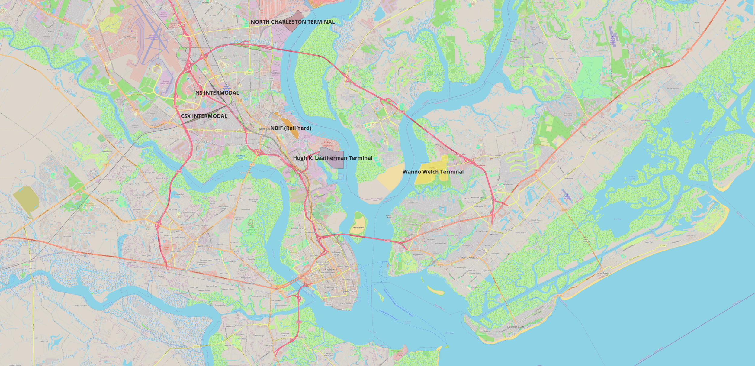
What the map makes clear: When public highways are used to substitute for missing rail access, transportation costs and congestion are shifted outside the port and onto taxpayers and commuters.
Proposed Operational Shift
This page evaluates a targeted operational adjustment: routing marginal container growth toward rail-integrated capacity rather than continuing to concentrate growth at a truck-dependent terminal.
The practical proposition is straightforward: migrate marginal container growth from the rail-deficient Wando Welch Terminal to the rail-integrated Hugh K. Leatherman Terminal. This is not a call to abandon legacy infrastructure. It is a measured shift in where new growth is routed as transportation constraints tighten and the costs of truck dependence rise.
End-state (planning horizon): The long-run objective is straightforward: Charleston’s container system minimizes public cost and highway dependence when large-scale container growth is routed to rail-served terminals (Leatherman and North Charleston) rather than to a terminal that requires recurring truck transfers across public interstates to reach rail.
Put plainly: if the Authority cannot produce a dated transition plan with measurable volume targets, then Wando’s dominance is not a necessity — it is a choice.
Legacy Design Context
Wando Welch Terminal was planned and expanded during a period when truck-centric distribution models were widely accepted and regional highway capacity constraints were less acute.
The question today is not whether Wando should exist. It is whether continuing to concentrate new growth at a rail-deficient terminal remains fiscally rational given modern congestion, taxpayer-funded workarounds, and the existence of a modern rail-integrated alternative.
Historical Precedent: Highway Expansion as a Substitute for Rail
Prior public discussions of port growth assumed that highway congestion could be managed through incremental roadway expansion rather than through changes in terminal-rail integration.
Historical context (2002): In a Statehouse push tied to new terminal ambitions, the proposed “fix” for congestion was to restripe portions of I-526 from four lanes to six and to expand truck routes—an early form of the same logic that has since escalated into a multi-billion-dollar highway and bridge challenge.
The lesson is not that growth is bad. The lesson is that a port strategy that treats public highways as internal port infrastructure will eventually collide with capacity constraints. Incremental roadway fixes do not resolve a structural rail constraint; they defer the consequences.
Underutilized Rail-Integrated Capacity
The Hugh K. Leatherman Terminal was constructed to provide modern, rail-adjacent container capacity but remains underutilized relative to systemwide needs.
This underutilization is not a market mystery. It reflects ongoing operational choices that continue to prioritize a legacy terminal with known structural limitations over a purpose-built, rail-adjacent facility.
Documented routing imbalance (FY 2025): SC Ports’ own “Total Pier Containers” reporting shows Wando Welch Terminal at 1,154,652 containers and Leatherman Terminal at 75,931 containers. That is 1,154,652 ÷ 75,931 = 15.2× more containers routed through a rail-deficient terminal than through a rail-adjacent terminal.

Supporting document: Total Pier Containers by Terminal (FY 2024 & FY 2025) (PDF) 3
This chart reports “Total Pier Containers” (physical container units) by terminal. It is presented here as provided by SC Ports.
Terminal Capacity: What SCPA Reports It Can Handle
SC Ports’ 2025 Annual Report describes container capacity at Wando Welch Terminal, full-buildout capacity at Leatherman Terminal, and the planned expanded capacity at North Charleston Terminal.2
| Terminal | Capacity (TEUs) | Status / Description (SCPA) |
|---|---|---|
| Wando Welch Terminal (WWT) | 2.4 million | Modernized; described as busiest container terminal |
| Hugh K. Leatherman Terminal (HLT) | 2.4 million | Full buildout capacity (three berths) |
| North Charleston Terminal (NCT) | 5.0 million | Future expanded terminal (capacity statement in Annual Report) |
Capacity arithmetic (SCPA-reported): NCT (5.0M) + HLT (2.4M) = 7.4M TEUs. Relative to WWT (2.4M), that is +5.0M TEUs of additional capacity and 7.4 ÷ 2.4 = 3.08× WWT’s reported capacity.
Based on SCPA’s own reported capacities, Charleston’s future container volume could be accommodated by North Charleston Terminal and Hugh K. Leatherman Terminal without reliance on Wando Welch Terminal over the long term.
This raises a legitimate planning question: whether continued concentration of volume at a truck-dependent terminal remains necessary once rail-integrated capacity is fully available elsewhere in the system.
Planning implication: Over a 20-year planning horizon, the data suggest that Charleston’s container system minimizes public cost and congestion if Wando Welch transitions out of large-scale container handling and that volume is shifted to rail-served terminals such as Leatherman.
Mismatch Between Infrastructure Capacity and Volume Routing
Existing transportation infrastructure capacity does not align with current container routing patterns, resulting in congestion where infrastructure is constrained and underuse where capacity exists.
While commuters experience persistent congestion on I-26 and I-526, the Port Access Road—one of the few highways in South Carolina built explicitly for port operations— remains underutilized. Its underuse, alongside congestion elsewhere in the port network, illustrates a practical mismatch between where capacity exists and where volume is routed.
Truck-to-Rail Distance Differential
The distance between terminal operations and rail access differs materially across the port system, with direct implications for truck mileage and public highway use.
| Terminal | Distance to Rail Head | Practical Impact |
|---|---|---|
| Wando Welch (legacy) | ~12 miles | Rail-bound containers require a recurring truck transfer across I-526 and the Don Holt Bridge. |
| Leatherman (modern) | ~1 mile | Terminal-to-rail moves can occur on a dedicated access connection rather than public interstate corridors. |
Truck-to-Rail Distance Differential: Terminal location relative to rail access materially affects truck mileage. Wando requires a multi-mile truck transfer for rail-bound containers, while Leatherman is positioned to support terminal-to-rail moves without relying on public interstates.
This difference is structural, not cosmetic. When a logistics system must use public highways to perform internal transfer functions, transportation demand and cost are shifted onto the surrounding region.
External Benchmark: Freight Routing and Infrastructure Response
An external benchmark helps illustrate how freight routing decisions can influence long-term infrastructure requirements.
In Southern California, container movements from the Ports of Los Angeles and Long Beach were historically distributed across multiple surface rail alignments and at-grade street crossings. As container volumes increased, these freight movements increasingly conflicted with urban traffic, prompting concern over congestion, safety, and reliability.
With limited geographic flexibility to relocate terminals or reorient freight flows, public agencies and rail operators pursued a consolidated infrastructure solution. The result was the Alameda Corridor, a 20-mile, largely grade-separated freight rail corridor designed to centralize port-to-rail movements and reduce reliance on surface streets.4
A central feature of the project is the 10-mile Mid-Corridor Trench, which carries three mainlines below grade to reduce conflicts with local roadways and improve operational reliability.4
This experience illustrates how reliance on public corridors for internal freight transfers can, over time, necessitate large-scale infrastructure responses when routing patterns become incompatible with surrounding land use and traffic conditions.
Charleston’s circumstances differ materially. The region has access to rail-adjacent container capacity on the Cooper River, allowing future growth to be routed with substantially less dependence on public highway corridors, subject to operational and policy choices.
Land Use and Opportunity Cost
Wando’s waterfront footprint is a long-term public asset whose opportunity cost depends on how intensively truck-dependent logistics functions are maintained over time.
This is not offered as a valuation claim. It is a reminder that routing decisions are not only operational; they also shape long-term land use, tax-base outcomes, and regional transportation burdens.
Measured Transition Strategy
A phased approach that redirects future growth—rather than displacing existing operations— allows capacity utilization to evolve without disrupting current port activity.
This proposal does not require closing Wando. It calls for a measured transition in where future growth is routed—one that reflects current transportation constraints and the existence of rail-integrated capacity that South Carolina has already funded.
Governance and Fiduciary Review
Governance and Fiduciary Review: An independent Legislative Audit Council (LAC) feasibility review is warranted to assess how alternative routing and terminal utilization scenarios affect transportation demand, infrastructure costs, and taxpayer exposure.
At minimum, such a review should:
- Model avoided or deferred highway expansion costs under alternative routing scenarios
- Quantify the long-run cost of truck-dependent rail transfers
- Compare long-term taxpayer outcomes under Wando-heavy vs. Leatherman-heavy growth routing
- Set clear, measurable utilization targets for rail-integrated infrastructure
Conclusion: Aligning Capacity, Routing, and Public Cost
South Carolina’s port system contains sufficient physical capacity, but improved alignment between terminal routing decisions and transportation infrastructure is necessary to control long-run public cost.
The Hugh K. Leatherman Terminal was built to reduce dependence on the Wando truck corridor. Leaving that capacity underused while expanding public highways elsewhere is not a neutral outcome—it is a policy choice with measurable fiscal and transportation consequences.
As illustrated by prior freight corridors such as the Alameda Corridor, when internal port movements rely on public transportation networks, long-term infrastructure expansion tends to follow routing patterns rather than correct them.
References
- Palmetto Railways / South Carolina Ports Authority, Intermodal Container Transfer Facility Briefing Memo (April 28, 2021), p. 75.
- South Carolina Ports, 2025 Annual Report, p. 8 (terminal capacity statements for WWT, HLT full buildout, and future NCT expansion).
- South Carolina Ports, Total Pier Containers by Terminal (FY 2024 and FY 2025).
- Alameda Corridor Transportation Authority (ACTA), Alameda Corridor Freight Rail Expressway Opens On Time and On Budget (April 12, 2002) (project cost and opening context); and ACTA, Alameda Corridor Mid (Mid-Corridor Trench) (10-mile trench / triple mainline description).